


Mendoza has three differentiated geographical structures: the Andean mountain to the west, plains to the east, and plateaus, mountains, and volcanoes to the south. The mountain range determines almost all the geography of Mendoza. Its land is practically located completely over a thousand metres above sea level.
The mountainous region occupies half of the west of the province and here the Andes Mountain Range reaches its highest peaks. This region is divided into three orographic units divided by longitudinal and transversal valleys:
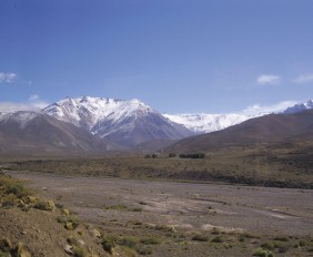
Main Mountain Range: it is a watershed, and it acts as a border line between Chile and Argentina. Its width decreases progressively from north to south, as well as the heights of its peaks, its mountain passes, its eternal snow and glaciers. The Aconcagua is located here. It is also called “Coloso de America,” and it has an altitude of 6962 metres above sea level; it is the highest peak in the world outside the “Himalaya system. ” Other high hills are the Juncal, measuring 6180 metres above sea level, and the Tupungato reaching 6800 m.a.s.l. in the international limit with Chile. Also extinct and lethargic volcanoes can be seen on this landscape, and also passes that allow the communication with Chile, such as the Pehenche.
Frontal Mountain Range: it runs east of the Main Mountain Range from the border with San Juan to Diamante River. It is a massif formed by various blocks with altitudes ranging from 5000 to 6000 m.a.s.l.; such as del Tigre, del Plata, del Portillo, de Santa Clara, de las Llaretas and del Carrizalito ridges.
Andean Foouthills: it is separated from the Frontal Mountain Range by Uspallata Valley. It goes from the limit with San Juan to Mendoza River, at the level of the area of Cacheuta. It is lower than the previous ranges, and it belongs to the Villavicencio Mountains with heights of up to 3000 m.a.s.l. (Cruz del Paramillo).
The east plains, or Travesías Cuyanas, are arid plains with xerophilous vegetation and large dune areas. Through it Mendoza, Tunuyán, Diamante and Atuel Rivers flow. These are used for irrigation in the northern and southern oases. In its far north-western part, “Cerrilladas Pedemontanas” are located. They divide the plain from valleys, such as Uco valley, and as they are much eroded they adopt the form of blades (as is the case of Tupungato), hillocks (as is the case of Lulunta), or badlands (as in the case of San Carlos and Rivadavia).
In the south of the province the relief is more complex and it has morphological characteristics which are typical of the Patagonia. The east plain spreads towards Llancanelo depression, a lake basin with swamps and salt fields from Llancanelo lake in its centre. The depression is surrounded by the mountain range to the west, by isolated mountain chains to the north (such as Bloque in San Rafael, divided into two parts by the Atuel Canyon), by the Nevado Mountain Chain to the east, and by the Payunia plateau to the south. This is a basaltic, steppe plateau, covered with scoria, with more than 800 isolated volcanoes where Payún Matrú stands out with its 3860 m.a.s.l.
Esta entrada también está disponible en: Spanish Portuguese (Brazil)
¿Qué te pareció la publicación?