


RIO ATUEL
The basin that feeds River Atuel has a mountain front of barely 50 Km., but it includes many important glaciers, such as glacier Las Lagrimas, and higher peaks than those on the main ridge, with Sosneado being its higher mountain, consisting of 5160 metres.
The discharge of river Atuel is formed by the so called Atuel, and by its junction, Salado River.
River Atuel starts at a height of 3500 metres, and it is fed by a series of ice tongues that descend from the Andes Mountain Range between Morado and Paso de las Leñas hills.
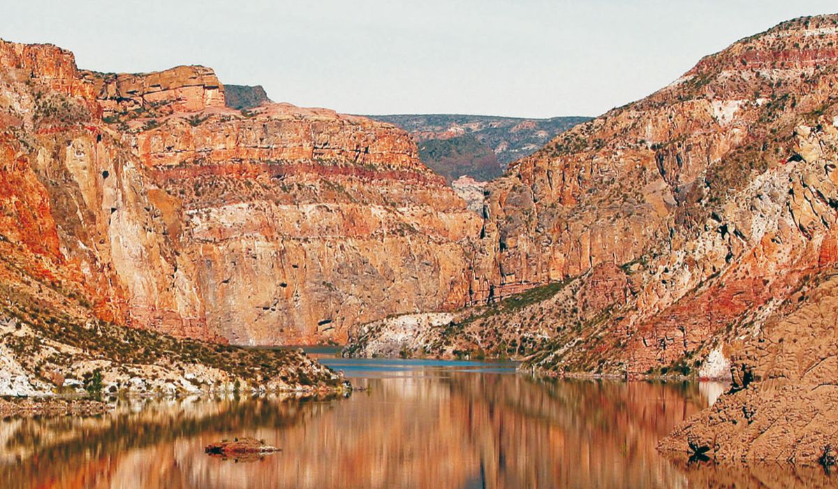
500 meters downstream from the bank reservoir El Nihuil, the river starts cutting through Sierra Pintada forming a canyon 50 kilometers long named “Cañón del Atuel”. This canyon ends in the last foothills of “Sierras de San Rafael.”
The longitudinal profile of the river is very representative and it shows very large slopes up to the seams; a soft slope (1.2%) up to dam El Nihuil and a great waterfall from this last point to the Rincón del Atuel (580 meters of incline in 45 kilometers) where a succession of important stations destined for generating hydropower and for irrigation are located. These are: Nihuil, Nihuil I, Nihuil II, Nihuil III, Valle Grande dam.
Atuel River flows into the San Rafael plains in the spot called “Rincón del Atuel”, and then it flows into the Desaguadero-Salado River, in the province of La Pampa..
VALLE GRANDE
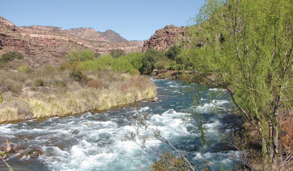
37 kilometers away from the city, we get to “Cañón del Atuel” and to the spot called “Valle Grande”. For getting there, we use Provincial Route No. 173, a fully asphalted route. We are then welcomed by lush vegetation next to the murmur of Atuel River, which runs through its bed of stones. The combination of all this offers us the possibility of enjoying special holidays coexisting with nature. The wall of the Valle Grande bank constitutes an immense mirror of emerald green water which invites us to practice swimming, diving, skiing, rowing, powerboating, rides in catamaran boats, windsurfing, etc.
In the surrounding areas, by the riverbanks that witness murmurs of years of geological history, we find hotels and cottages that offer all kind of services to the tourist. Also, the area has numerous campsites, used by campers that include all kind of services, such as: restrooms, electric power, forested lands, water, bathing places or swimming pools, food shops, restaurants, and regional handcrafts.
To fully enjoy our visit, we will have time to develop recreational activities in which you can choose between having a ride on a catamaran boat through the Valle Grande reservoir, or doing rafting (trips on inflatable rubber boats) through the Atuel River.
Rafting. An exciting adventure on the waters of Atuel River. The famous Valle Grande rafting captivates the visitor with its amazing landscape.
This descent trough “white water” using inflatable boats captivates thousands of enthusiastic visitors of all ages that wish to live the experience being protagonists and, at the same time, forming part of the landscape.
Catamaran at Valle Grande Lake. The amazing views of Valle Grande Lake, together with the curious rocky formations of Cañón del Atuel, is an obligatory tour in San Rafael. You, together with your family and friends, will be able to visit the lake through rides in Catamaran boats, equipped with the necessary comfort and the required safety to fully enjoy it.
We propose you a trip through Valle Grande Lake, visiting every corner of this emerald green mirror of water
DIQUE VALLE GRANDE
The Valle Grande dam has a closure of lightened structure made of concrete. It has a longitude of 300 m and its crest elevation is of 815.65 meters above sea level. It has a maximum height of 115 meters from its foundation. It has a discharge capacity of 600 m3/s. For its construction, 700 000 m3 of concrete were used and it was inaugurated in 1964. It has a discharge system for irrigation. Conduction is used to feed a turbine of 25MW of power. For its generation it uses the discharge set for irrigation General Department of Irrigation. The reservoir has a capacity of 164 hm3, with a useful volume of 162.20 hm3. It shows sedimentation of fine material. In the authorized areas, one can practice diving, water skiing, rowing, power boating, rides on catamaran boats, windsurfing, sport fishing, and photographic safaris; and, only in some places, bathing is allowed.
We finally arrive at the Viewing point of the Valle Grande Lake, an immense emerald green mirror of water in which we can observe the formation known as “The Submarine.”
All throughout the visit we will see the most peculiar natural sculptures such as: Museo de Cera (Wax Museum), Sillón de Rivadavia (Rivadavia’s armchair), El Lagarto (The Lizard), Los Viejos (The Old People), Los monstrous (The monsters), La Ciudad Encantada (The Enchanted City), EL Mendigo (The beggar), Los Jardines Colgantes (the hanging gardens), among others.
ATUEL CANYON
Upwards of the Valle Grande Dam one comes across the Atuel Canyon, a living presence of the world’s origins sculpted by wind and rain and shaping the most extraordinary formations. Some of them are so perfect that they have been baptized through the years: “The Wax Museum”, “The Old Men”, “The Monsters”, “The Beggar”, “The Hanging Gardens”, “The Haunted City” and “The Lizard” amongst many others.
The geologic formations of Cañón del Atuel, made by the natural force of water and wind allow us to enjoy natural sculptures incorporated to the landscape.
El Nihuil waterfall or cascade, where the reservoir is built, is where Cañón del Atuel starts.
This geographical feature created by Atuel River, that drilled a hole on the Sierra Pintada massif, originated what we know today as Cañón del Atuel. There, humans knew how to embed, in harmony with the environment, works of hydraulic engineering of magnitude which constitute a hydro electrical complex of four dams, two reservoirs and four central stations.
The place named Nihuil, which means “there is a pass”; also for others, it is a deformation of the word Nahuel, which means “tiger”.
The Atuel River, in its millennial trip carved, all the way long on its 45 kilometers, formations of an indescribable beauty and discovering the different geological layers.
Today, at Cañón del Atuel, tourists come to enjoy the natural formations, and also scientists that are attracted by the prehistoric deposits, described in Archeological studies.
The minerals and rock formations of the Canyon mesmerize and marvel with their shapes, and seen from the buses whilst they go around the steep curves, they appear and disappear looking like slippery sculptures.
Next to the attractions of the natural landscape, the hydroelectric complex Nihuil is incorporated, with its dams and mirrors of water, which in harmony with the environment, offer different alternatives to the visitor.
Atuel Canyon Leyend. In the South of what is today the province of Mendoza, there lived the tribe of the cacique Talú. Talú’s father died when he was very young, but in spite of his young age, he assumed his role and governed his people wisely.
Life in the tribe was peaceful and happy, but a great drought hit the region. The old people and the youngest children were the most affected by the lack of water, and soon, the first deaths appeared. Without hesitating, Talú called his men and they departed in search of water for their people.
In many occasions, they went through territories that they had never gone through before, but they only found dry and parched earth due to the burning sun. In one of these expeditions, Talú met a beautiful woman that lived alone in a valley. The young cacique talked to her and decided to take her with him to live in his town, where she got integrated easily. A deep love was born between them and she confessed him that her name was Clara, that she was an orphan and that she had lived alone in the valley for many years. After many months, they decided to get married and a short time after, they had a child who they named Atuel.
The prolonged draught had already taken the lives of many children and old people. White men did not take long to notice the despairing situation and decided to attack to take control of the territories. Battles were violent, but the weakened indigenous people were finally defeated. All the men of the tribe, including Talú, were killed. In the middle of such confusion, Clara was able to hide with her newborn baby, and, when the white men finally left the place, they only left widows, orphans and some dying men behind.
Clara took little Atuel in her hands and walked towards the high mountains, there, where the sun sets. She climbed to the top of one of the peaks and asked the gods for water so that the survivors of the tribe could be saved. The time passed by and nothing happened, so Clara decided to offer her and her child’s life to the gods.
At the moment of dying, each of them dropped a tear and from them, a heavy flowing river rose; which opened its way through the dry earth until reaching the village.
Women gave water to their children and, after a long time, laughter was heard again in the village. The elderly women looked for Clara and her son, but, as they couldn’t find them, they understood that they had been the responsible for that miracle to happen.
The river brought again life to the place, and in the nights, its stream lulled the village with a special sound, similar to the crying of a baby. Then, everybody understood that the water kept Atuel’s spirit, and named the river after the little heir.
CENTRAL 3
Central station No 3 “Ingeniero Rivas” This one exploits a waterfall of 75 meters, located between the discharge of the turbines El Nihuil II, upstream and the Valle Grande dam. Its installation flow rate is of 78 meters per second. The installation is of the outside type, it has two turbines of vertical axis, with a unit power of 26 MW, and it has been working since 1971.
CENTRAL 2
We arrive at Central station No. 2, which has no name. We can see on the right a metal grid made of steel sheets to protect the central station from landslides –very frequent in this area. The central station is of the outside type and it has six turbines with an installed flow rate of 78 m3/s. At the exit of its restitution we find the tail end of the reservoir generated by the Tierras Blancas dam.
CENTRAL ING. MAGGI
Hydroelectric central station “Engineer Maggi”: It was named after the engineer in charge of the project, who died during the construction of the central station. There are four turbines placed vertically that hit the water perpendicularly.
Below us, the water intakes have been piped and are moved from the dam to the central station. We see AISOL dam. AISOL Dam (NIHUIL I) is located immediately after downstream the restitution of Nihuil I central station, and it is a concrete structure of the gravity type, of straight plant, with a longitude of 85 meters. It has four turbines of vertical axis and its unit power is of 18.45 MW, with a waterfall of 158 meters and 11.75 m³/s. It has been working since 1957.
Los Nihuiles complex belongs to the French capitals Group INIZA –formerly, it belonged to “Agua y Energía”
EL NIHUIL
Emerging from Cañón del Atuel, through a sinuous slope, we find the immensity of the lake that forms El Nihuil dam, of 9600 hectares and, in which core, varied species of fish fauna come to life. This invites the fisher to fully enjoy their favorite sport. It also allows to appreciate a unique colorful show, when the windsurfing amateurs display hundreds of multicolor sails; or the water skiing amateurs, who slide on this quiet water. Sport fishing and water sports make of this dam, a place not to be missed when we have to choose. On the right margin, we find “Villa El Nihuil” (El Nihuil village). Its inhabitants are mainly the plant operators and their families. This is a neighborhood that counts with all type of services: a Municipal delegation, a chapel, a health care center, telephone service, Schools, and also a campsite. To come back to San Rafael, we use Provincial Route No. 180 joining National Route No. 144, passing through Cuesta de los Terneros (where we find a viewing point to the City), the Cuadro Benegas district and we enter the city through National Route No. 143.
The first bank “El Nihuil” is made of concrete; it has a longitude of 324 meters and has a maximum height of 26 meters. It was officially inaugurated in 1948 and it has a longitude of 150 meters. On the left margin, we find the headwork that conducts the flow rates toward the hydroelectric central station Nihuil I, at 7 km, called Engineer Maggi. The bank represents the most important work of hydroelectric power of the region of Cuyo. It is named after a cacique that avoided the military men by crossing through the narrowest place of the Atuel River. We shall not forget that this river was the boundary between the aboriginal settlements and the militias by the end of the 19th century, when these lands were contested to develop in them agricultural and livestock activities. By 1948, the construction of the dam had ended, which generated an enormous artificial lake, which at first, had as purpose to provide a vast region with irrigation water; later, its natural inclines were also used for the generation of hydroelectric power. Here, we find the “Club de Pescadores” (Fishermen’s club).
Esta entrada también está disponible en: Spanish Portuguese (Brazil)
¿Qué te pareció la publicación?